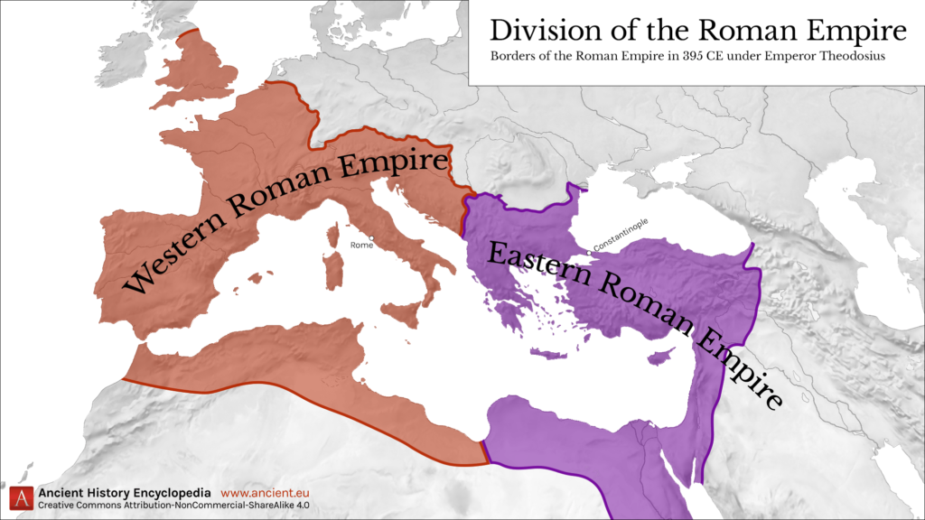
Roman and Byzantine geography laid significant foundations for the modern understanding of the world, blending exploration, mapping, and scientific thought. While the Romans expanded their empire across Europe, Africa, and Asia 🌍, they also contributed to the development of geography as a scientific discipline 📚. The Byzantine Empire, which emerged from the eastern half of the Roman Empire, continued and preserved these geographical traditions 🏛️, shaping maps, exploration, and geographic theories for centuries.
Roman Geography (1st Century BCE – 5th Century CE)
The Romans were known for their administrative prowess 🏛️, and they were among the first to apply geography in practical ways for governance, military strategy, and trade. Roman geographers worked to map the Roman Empire, including cities, roads, and trade routes.
- Ptolemy and the Geographia 🗺️:
- One of the most influential figures in Roman geography was Claudius Ptolemy (c. 100-170 CE), an Egyptian-Greek scholar whose work Geographia laid the foundation for modern cartography 🗺️. This book described the world using a coordinate system based on latitude and longitude 📏. It was revolutionary, as it allowed geographers to map locations accurately and was used for centuries by scholars in both the Roman and Medieval worlds.
- Ptolemy’s maps weren’t entirely accurate by today’s standards, but they provided a framework for understanding the Earth’s surface 🌍 and were widely influential in Europe, especially during the Renaissance.
- Roman Road Networks 🛣️:
- The Romans also pioneered the development of extensive road networks 🚗 throughout their empire, which was crucial for trade 🚢, military expeditions ⚔️, and communication 🗣️. Their understanding of geography was practical, aimed at maintaining control over their vast territories. The saying “All roads lead to Rome” 🌍 is a testament to how central the Roman road system was.
- Roman maps focused on practical features like roads, cities, rivers, and borders, and they played an essential role in the expansion of the empire.
- Agricultural and Regional Mapping 🌱:
- Roman geography also included regional mapping, which was particularly focused on the land and climate for agricultural purposes 🌾. Many Roman geographers wrote about the agricultural capabilities of different regions, which influenced the development of settlements and trade.
Byzantine Geography (5th Century CE – 15th Century CE)
As the Roman Empire fell in 476 CE, the Byzantine Empire continued to flourish in the East, with Constantinople (modern-day Istanbul) as its capital 🏙️. The Byzantines inherited and expanded upon Roman geographical knowledge 🗺️, though their contributions were often centered on preservation and interpretation of earlier works, rather than new discoveries.
- Preservation of Ancient Knowledge 📚:
- The Byzantines were key in preserving Greek and Roman knowledge during a period when much of Europe was in the Dark Ages 🏰. Byzantine scholars maintained libraries 📖 and studied classical works like those of Ptolemy and Strabo, ensuring that geographic knowledge survived through centuries of turmoil in the West.
- Byzantine scholars like Cosmas Indicopleustes (6th century CE) challenged earlier Greek and Roman ideas, proposing that the world was flat, not spherical 🌍. Though his theories were not widely accepted, they were part of the vibrant debates about geography during this period.
- Christian Influence on Geography ✝️:
- Byzantine geography was deeply influenced by Christian theology. Maps from this era often depicted the world in a religious context, such as the T-O maps, which showed Jerusalem 🌍 at the center of the world, symbolizing its importance in Christianity ✝️.
- The Holy Land (Israel and surrounding areas) was often at the center of these maps 🗺️, with the oceans (O) surrounding the continents (T). These maps reflected the Byzantine worldview, where religion intertwined with geography.
- Byzantine Cartography 🗺️:
- While the Byzantines weren’t as focused on exploration as the Romans, their maps often included the known territories of Europe, Asia, and Africa 🌍. They made efforts to document the Mediterranean world, including cities, trade routes, and the boundaries of empires.
- Byzantine world maps were more symbolic than strictly geographic. They showed the Earth’s major continents in stylized forms, and rather than focusing on precise measurements, they depicted religious or political boundaries.
- Ibn Battuta and Byzantine Influence 🌍:
- Byzantine geographical knowledge influenced later Islamic scholars, including Ibn Battuta, a famous Moroccan explorer, who used Byzantine maps and ideas during his extensive travels across Africa, Asia, and Europe 🌍.
- The Byzantines also influenced early European Renaissance geographers, who rediscovered and expanded upon Byzantine and ancient Greek geographic ideas.
🗺️ Roman and Byzantine Geography in the Larger Context
The Romans and Byzantines contributed significantly to the evolution of geographical thought 🧭. While the Romans were more practical and systematic in their geographic studies, the Byzantines played a crucial role in preserving and interpreting ancient knowledge, ensuring that future generations could build upon their insights.
- Roman contributions to geography focused on the practical aspects of mapmaking, administration, and military strategy 🏛️, while the Byzantines focused more on religious symbolism, the preservation of knowledge, and the interpretation of earlier works 📚.
- Both civilizations contributed to the eventual rediscovery of geography during the Renaissance, when Ptolemy’s Geographia was once again studied and used as a basis for accurate maps 🗺️ of the world.
🌍 Legacy of Roman and Byzantine Geography
- The Roman road networks 🌍 provided the foundation for the development of trade, exploration, and even map-making, ensuring their dominance in Europe for centuries.
- The Byzantine preservation of knowledge 📚 played a crucial role in the survival of ancient Greek and Roman texts, many of which became the basis for modern geography.
- The T-O maps and religiously influenced maps created by the Byzantines would later be superseded by more accurate, scientifically based maps as exploration expanded.
In conclusion, Roman and Byzantine geography laid the groundwork for future cartography and exploration 🗺️, contributing to our modern understanding of the world 🌍.


